Teaching Geography Holistically Through the Stathine–Coexon Framework
From memorising places to understanding the interconnected reality of our planet
1. The fundamental question: What should a student learn from geography?
Imagine a student who can name all seven continents, locate the major rivers of India, identify mountain ranges on a map, and correctly answer questions about the world’s climate zones. The student scores well in examinations, yet throws plastic into a river, does not understand why a city is running out of groundwater, and cannot explain how the food on the dinner table connects a farmer, a monsoon, a soil ecosystem, a transport network, and an international market.
Has this student learned geography?
The student has acquired geographical information but may not yet understand geographical reality. This distinction provides the starting point for redesigning geography education through the Stathine–Coexon Framework.
Geography should not be taught merely as the study of places, landforms, countries, rivers, and climates. It should help students understand how the Earth works as an interconnected system, how living beings depend on their surroundings, how human activities transform the planet, and how geographical understanding can guide decisions that improve life.
The purpose is not to replace geographical knowledge with philosophy. It is to connect the facts, concepts, scientific explanations, human experiences, and practical decisions that give those facts meaning.
The Stathine–Coexon Framework offers a philosophical architecture for organising this learning around reality, interconnectedness, coherence, and the progressive reduction of contradictions between what we believe about the world and what we discover about it.
The framework’s central educational question becomes:
How can geography help a student move from seeing isolated features of the Earth to understanding the relationships that sustain life on it?
That question can transform not only how geography is taught, but also how students learn to think.
2. The first principle: Begin with reality, not the textbook
Children encounter geography long before they encounter the subject in school.
They experience the heat of summer, the arrival of monsoon clouds, the changing length of daylight, the taste of water, the soil in a garden, the distance to school, the trees along a road, and the differences between crowded and open spaces. These experiences are the raw material from which geographical understanding can develop.
Traditional instruction often reverses this natural process. Students are given definitions, diagrams, classifications, and textbook descriptions before being encouraged to investigate the reality those descriptions represent.
A holistic approach reverses the sequence.
Begin with something the student can observe. Ask what is happening, where it is happening, what influences it, how it connects to other things, and what evidence would help explain it. Introduce geographical concepts when they help the student make sense of the observation.
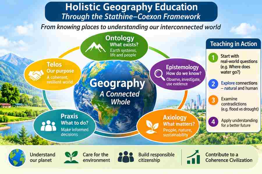
For example, instead of beginning a lesson with the definition of a river basin, ask students to investigate where rainwater goes after falling on their school grounds.
Does it enter the soil? Does it collect in a depression? Does it flow towards a drain? Where does that drain lead? What happens when the drain is blocked? Where might the water eventually reach?
The teacher can then introduce slope, runoff, infiltration, drainage networks, watersheds, and river basins. Each concept becomes a tool for understanding something real rather than a definition to be memorised.
The student learns not only what a river basin is, but also why the concept matters.
This is the first educational implication of the Stathine–Coexon Framework: knowledge should progressively improve the learner’s ability to understand reality, rather than merely increase the quantity of information stored in memory.
The textbook remains important, but its role changes. It becomes a source of explanations, evidence, concepts, and methods that students use to interpret the world.
3. The Stathine–Coexon perspective: Connecting the Earth, life, and understanding
To make geography holistic, we need a way to connect the many kinds of knowledge that the subject contains.
Geography includes physical processes such as weathering, rainfall, ocean circulation, and plate tectonics. It also includes living systems, agriculture, settlements, migration, trade, culture, political boundaries, and the distribution of resources. These are not separate realities. They are different aspects of a world in which physical, biological, and human processes interact.
The Stathine–Coexon Framework provides a philosophical lens through which to explore these relationships.
Stathine: Understanding the conditions in which the world exists
Within the framework, Stathine is defined as a static, non-depleting, borderless field of energy in which elements interact and exist. This is a foundational hypothesis of the framework, not an established scientific description of the Earth’s physical environment.
When teaching geography, it is important to distinguish this philosophical conception from the scientific concepts used to explain observable phenomena. A student should learn about gravity, solar radiation, the Earth’s magnetic field, atmospheric circulation, and the transfer of energy through ecosystems using the relevant scientific evidence and theories.
The educational contribution of the Stathine concept is to invite a broader philosophical question: What are the conditions that allow different forms of existence and interaction to occur?
That question can encourage students to explore the relationships between matter, energy, space, and life without confusing philosophical interpretation with experimentally established explanations.
For example, when studying the water cycle, students can investigate solar energy, evaporation, condensation, precipitation, infiltration, and runoff. They can then consider how these processes connect different parts of the planet and make terrestrial life possible.
The scientific explanation must remain scientifically grounded. The Stathine hypothesis can provide an additional philosophical perspective, provided its status is clearly identified.
Coexon: Understanding the learner as an active interpreter of the world
The Stathine–Coexon Framework proposes Coexon as a sentient life atom capable of organising information and communicating with the holobiont’s neurological brain. This is a hypothesis of the framework, not an established scientific fact.
Its educational relevance can be explored at two levels.
First, the framework places importance on the learner’s capacity to organise information into coherent understanding. In practical classroom teaching, this means helping students connect observations, prior knowledge, explanations, and experiences instead of treating learning as the accumulation of disconnected facts.
Second, the framework invites the question of how a living being makes sense of its surroundings and translates understanding into action.
A student who understands why a neighbourhood floods may recognise that a blocked drain is not merely an isolated inconvenience. It is part of a larger relationship involving rainfall, topography, land use, drainage infrastructure, and human decisions. That understanding may lead the student to investigate the problem, discuss it with others, and propose a solution.
We do not need to establish the Coexon hypothesis scientifically to use these questions as educational prompts. The hypothesis should be explored separately from evidence-based findings in cognitive science, neuroscience, and geography.
The central pedagogical principle is that the purpose of geographical learning is not simply to know more about the Earth, but to develop a more coherent understanding of the relationships that shape it.
4. The five dimensions of holistic geography education
A useful way to apply the framework is to organise geography learning around five dimensions: ontology, epistemology, axiology, praxis, and telos.
These dimensions address five questions that together turn geography from a collection of topics into a connected learning experience.
DimensionFundamental questionApplication to geographyOntologyWhat exists, and how is it organised?Understand the Earth’s physical features, atmosphere, water, living systems, human settlements, and their relationships.EpistemologyHow do we know what we claim to know?Observe, measure, map, investigate, compare evidence, and distinguish established explanations from assumptions.AxiologyWhat matters, and why?Examine the value of biodiversity, water security, cultural diversity, livelihoods, fairness, and environmental protection.PraxisHow should understanding guide action?Use geographical knowledge to improve water management, land use, disaster preparedness, and community planning.TelosWhat larger purpose should learning serve?Develop people who can understand their place in the world and contribute to a more resilient, harmonious relationship between humanity and the Earth.
Consider a lesson on forests.
The ontological dimension examines what forests are, including their soils, vegetation, animals, water relationships, and human uses.
The epistemological dimension asks how we know whether a forest is healthy. Students might examine tree cover, species diversity, satellite imagery, rainfall records, and field observations.
The axiological dimension explores why the forest matters to different groups. A local community may depend on it for food and livelihoods, while conservationists may emphasise biodiversity and scientists may study its role in carbon storage and climate regulation.
The praxis dimension asks what should be done when forest use conflicts with conservation or when a forest is degraded.
The telos dimension asks what kind of relationship between people and forests should guide decisions across generations.
All five dimensions concern the same forest. Their connection gives the student a more complete understanding than studying tree species, forest types, and definitions in isolation.
The dimensions should not become five additional chapters that students must memorise. They should become a way for teachers to plan lessons and help students ask better questions.
5. Teach relationships before classifications become isolated knowledge
Geography textbooks often organise content into convenient categories: physical geography, human geography, economic geography, and environmental geography. These divisions are useful for learning, but the real world does not follow the boundaries of a textbook.
A mountain range, for example, influences rainfall patterns, river systems, soil formation, vegetation, agriculture, settlement, transportation, and cultural exchange. The effects vary with local conditions, technology, and human choices.
If students learn mountains only as landforms formed by geological processes, they understand one part of the subject. If they also investigate how mountain systems influence human life, they begin to think geographically.
This approach is consistent with established geography education. The Geographical Association’s curriculum framework connects the concepts of place, space, Earth systems, and environment with organising concepts such as time, scale, diversity, interconnection, and interpretation. The framework proposed here builds on that disciplinary foundation by adding the Stathine–Coexon Framework’s explicit emphasis on coherence, the examination of assumptions, and the relationship between understanding and action. Geographical Association
The teacher can develop this approach by asking students to follow connections across three levels.
At the local level, investigate the immediate environment: the school, the neighbourhood, the local pond, a nearby agricultural field, or the source of household water.
At the regional level, examine the larger geographical systems that influence local conditions: a river basin, a mountain range, a climatic zone, a transport corridor, or a regional agricultural economy.
At the global level, investigate the wider relationships that connect distant places: ocean circulation, atmospheric processes, international trade, migration, climate change, and the movement of resources.
The learning sequence moves outward from the familiar without becoming trapped within it. Students discover that their locality is not an isolated unit but part of larger systems, while also recognising that global processes have different consequences in different places.
The objective is not to force every topic into a grand theory of everything. It is to identify the connections that genuinely help explain the geographical phenomenon under investigation.
6. A practical example: Teaching the geography of water
Let us take water as the first model for teaching geography holistically. Water is an excellent starting point because it connects nearly every major dimension of the subject, from physical geography and ecology to agriculture, economics, culture, governance, and human wellbeing.
Instead of dividing the topic immediately into the water cycle, rivers, groundwater, irrigation, and water conservation, the teacher begins with a question:
Where does the water that sustains our lives come from, where does it go, and why do some places have too much water while others have too little?
This question becomes the thread connecting the lesson.
Stage 1: Observe reality
Ask students to investigate their household or school water supply. Where does the water originate? Does it come from a river, reservoir, lake, or groundwater source? How is it treated and transported? Where does wastewater go?
Students may initially offer different answers. Some may assume that groundwater is replenished immediately by rainfall. Others may believe that water disappearing into a drain is no longer part of the natural water cycle.
Rather than correcting every assumption immediately, the teacher records the questions and helps students investigate them.
The first learning outcome is awareness: students recognise that something they take for granted is part of a larger geographical system.
Stage 2: Build the scientific explanation
The teacher introduces the water cycle, groundwater recharge, surface runoff, river basins, watersheds, evaporation, and precipitation.
Students use diagrams and maps to understand the processes and identify the connections between them. They investigate why rainfall alone does not determine water availability: geology, soil characteristics, vegetation, slope, evaporation, water demand, and infrastructure also matter.
The teacher distinguishes observations from explanations. For example, observing that a well has less water than last year is evidence of a change, but it does not, by itself, establish why the change occurred.
Students must investigate possible explanations rather than accept the first plausible story.
Stage 3: Connect natural systems with human systems
Now introduce agriculture, urbanisation, industry, population distribution, and water governance.
Students discover that water availability depends not only on natural supply but also on how people use, distribute, store, and manage water.
A region may receive substantial rainfall yet experience seasonal shortages because water arrives unevenly, storage is inadequate, demand is high, or groundwater extraction exceeds recharge. Another region may receive less rainfall but manage its available water more effectively.
The point is not to label one region as good and another as bad. It is to identify the interacting conditions that explain different outcomes.
Students also explore the consequences of water scarcity for health, education, livelihoods, food production, and social relationships.
Geography now becomes a way of understanding why apparently separate problems often share underlying causes.
Stage 4: Examine contradictions
The Stathine–Coexon Framework places particular importance on identifying and reducing contradictions in understanding.
A water lesson can bring this principle into practice through questions such as:
- Why might a city experience flooding during the monsoon and water shortages a few months later?
- Why might a community protect a local pond while another group views the same land as an opportunity for construction?
- Why can increased irrigation improve agricultural production in the short term but contribute to groundwater depletion over time?
- Why can a policy designed to improve water availability in one location create difficulties for people elsewhere?
Students investigate each apparent contradiction using evidence, causal reasoning, and different geographical perspectives.
They learn that two apparently conflicting observations can both be true under different conditions. They also learn that resolving a contradiction sometimes requires changing an assumption, gathering additional evidence, or recognising a trade-off rather than searching for a single simplistic answer.
Stage 5: Translate understanding into action
Finally, ask students to identify a water-related issue in their school or community and propose an evidence-based response.
They might estimate water consumption, examine rainwater harvesting, investigate leaking pipes, map local drainage, or study whether a nearby pond is receiving adequate inflow.
Students should explain what they observed, what they believe is happening, which evidence supports their explanation, what remains uncertain, and what action they recommend.
A successful lesson therefore produces more than a correct examination answer. It develops the capacity to understand a geographical problem and respond constructively.
This five-stage approach can be summarised as:
Observe → Explain → Connect → Investigate contradictions → Act.
It is a practical teaching sequence inspired by the Stathine–Coexon Framework, not a replacement for the scientific methods and disciplinary knowledge of geography.
7. How to make every geography topic holistic
The water example can be generalised into a planning method that teachers can apply to any geographical topic.
TopicBegin with realityConnect the dimensionsPractical learning outcomeMountainsWhy do mountain regions differ from surrounding plains?Geology, climate, rivers, ecosystems, settlements, tourism, transport, and hazards.Evaluate development proposals in a mountain region.ClimateWhy do temperatures and rainfall vary between places?Solar energy, atmospheric circulation, landforms, vegetation, oceans, and human activities.Interpret local weather and climate information and assess relevant risks.AgricultureWhy do farmers grow different crops in different places?Soil, rainfall, temperature, irrigation, markets, technology, labour, and public policy.Compare agricultural choices and their environmental and economic consequences.PopulationWhy do people settle, migrate, or leave particular places?Employment, resources, transport, public services, hazards, culture, and demographic change.Analyse migration patterns and their effects on communities.UrbanisationWhy do cities grow, and why do their problems differ?Land use, housing, transport, water, employment, pollution, infrastructure, and governance.Develop an evidence-based proposal for improving a neighbourhood.OceansHow do oceans influence life far beyond their shores?Ocean currents, climate, marine ecosystems, fisheries, trade, and coastal settlements.Explain the connections between marine systems and human livelihoods.Natural hazardsWhy do similar hazards produce different levels of damage?Physical processes, settlement patterns, infrastructure, preparedness, vulnerability, and governance.Prepare a geographical risk assessment for a local area.International tradeHow does a product connect distant places?Resources, production, transport, energy, labour, markets, and consumption.Map a product’s geographical journey and assess its wider effects.
The table should not be interpreted as a requirement to include every dimension in every lesson. Teachers should select the relationships that matter most to the topic and the students’ level of understanding.
A lesson on the formation of a volcano must first teach the geological processes accurately. Connections to settlement, agriculture, tourism, or disaster preparedness can then deepen the learning where appropriate.
Likewise, a lesson on population distribution requires demographic knowledge and spatial reasoning, not merely a general discussion of interconnectedness.
Holistic teaching means connecting the parts without losing the integrity of each part.
That distinction is essential. Without sufficient subject knowledge, holistic education can become a collection of broad conversations that leave students unable to explain the world precisely.
8. Teach students how to distinguish knowledge from assumptions
A central educational objective of the Stathine–Coexon Framework is to help learners understand reality without allowing unexamined assumptions to substitute for evidence.
Geography offers many opportunities to develop this ability because geographical explanations often involve multiple causes, different scales, uncertain evidence, and competing interpretations.
Consider the statement: Deforestation causes flooding.
The statement can be useful, but it is incomplete if treated as a universal explanation. The effects of deforestation depend on factors such as the location and extent of forest loss, soil characteristics, rainfall intensity, slope, land use, and the drainage system. Flooding can also result from other factors, including extreme rainfall, inadequate drainage, river dynamics, and development on floodplains.
Students should learn to refine the statement by asking:
- What exactly is being claimed?
- What evidence supports the claim?
- Under what conditions is the explanation likely to apply?
- What other causes should be considered?
- What observations could challenge or strengthen the explanation?
- How confident should we be in the conclusion?
These questions teach students to distinguish a plausible explanation from a well-supported one.
They also make it possible to discuss uncertainty without treating all explanations as equally valid. An explanation supported by reliable measurements, established mechanisms, and converging evidence deserves greater confidence than one based only on intuition.
The same method applies to claims about climate change, population growth, natural disasters, agricultural productivity, migration, and resource scarcity.
Students gradually learn that understanding is not demonstrated by defending an initial opinion. It is demonstrated by the ability to improve an explanation when better evidence becomes available.
Using AI as a geographical learning partner
AI can extend this practice by allowing students to question explanations, request alternative hypotheses, compare interpretations, and identify gaps in their reasoning.
For example, a student investigating urban flooding could ask an AI system to identify possible causes. The student would then examine which causes are relevant to the selected location and verify factual claims against appropriate sources, maps, measurements, and expert research.
The AI should not be treated as the final authority. It may provide incorrect information, omit important causes, or present uncertain explanations confidently.
The teacher’s role is to help students evaluate the answers rather than simply collect them.
This is an opportunity to apply the Stathine–Coexon Framework’s emphasis on truth-oriented understanding: use questions and counterarguments to improve the explanation until it becomes more consistent with the available evidence.
9. Assessment: Test geographical understanding, not just recall
If teachers want students to develop holistic geographical understanding, assessments must reward that understanding.
Traditional questions such as Name the longest river in a country or Define weathering can test essential knowledge. They should not disappear. Students need accurate facts, concepts, terminology, and map skills to reason effectively.
However, these questions should be complemented by tasks that reveal whether students can use their knowledge.
Consider three levels of assessment for a lesson on river systems.
Level 1: Knowledge. The student identifies the major components of a river system and defines a watershed.
Level 2: Explanation. The student explains how rainfall, slope, soil, vegetation, and land use can influence runoff and river flow.
Level 3: Integrated understanding. The student examines a hypothetical or real catchment experiencing flooding and seasonal water shortages, analyses relevant evidence, identifies plausible causes, and recommends appropriate measures while acknowledging uncertainty and trade-offs.
The third task requires the student to bring knowledge together. It does not make the first two levels unnecessary; it depends on them.
A useful assessment rubric could examine five capabilities:
CapabilityWhat the teacher looks forFactual accuracyAre geographical facts and concepts used correctly?Causal reasoningCan the student explain how and why a phenomenon occurs?Systems understandingCan the student connect relevant physical, biological, and human processes?Evidence and uncertaintyCan the student distinguish observations, explanations, assumptions, and unresolved questions?Constructive applicationCan the student use geographical understanding to evaluate options or recommend an appropriate response?
The aim is not to give marks for agreeing with a teacher’s preferred worldview. Students should be assessed on the accuracy of their knowledge, quality of reasoning, use of evidence, and ability to justify conclusions.
That makes assessment a tool for improving understanding rather than merely ranking students.
10. A geography curriculum organised around progressive understanding
The same principles can shape the entire geography curriculum, from early childhood to advanced study.
At the earliest stages, children can explore their immediate surroundings. They can observe sunlight and shade, identify directions, describe familiar places, compare surfaces, follow the route from home to school, and investigate where rainwater collects.
As their knowledge develops, they can begin connecting observations to processes. They learn why rivers flow downhill, why temperatures vary, why certain crops grow in particular conditions, and why settlements emerge in particular locations.
At the next stage, students examine interacting systems. They investigate river basins, climatic regions, ecosystems, population patterns, transport networks, and urban development. Maps, graphs, fieldwork, and numerical data become increasingly important.
Older students can investigate complex geographical questions that require the integration of physical processes, human behaviour, economics, politics, and environmental change. They can evaluate evidence, compare explanations, model possible futures, and analyse competing interests.
At advanced levels, geography can become a powerful interdisciplinary field connecting earth science, ecology, economics, public policy, data science, and spatial analysis.
The progression is not simply from easy topics to difficult ones. It is from recognising features, to explaining processes, to understanding relationships, to evaluating systems, and finally to making well-reasoned decisions under real-world constraints.
This progression is compatible with established geographical curriculum principles, which emphasise building knowledge over time, developing investigative skills, and revisiting important concepts with increasing depth. GOV.UK
Geography should also preserve the importance of place
A holistic curriculum must not become so focused on abstract systems that students lose their connection with actual places.
The same amount of rainfall can have different consequences in a forest, a desert, a densely built city, and an intensively cultivated agricultural region. The same infrastructure investment may benefit one community more than another. A global process is experienced through local conditions.
Students therefore need detailed knowledge of real places, including their physical characteristics, people, histories, cultures, economies, and environmental challenges.
They should study their own surroundings while also learning about places beyond their immediate experience. Local knowledge provides an anchor, but geographical education should expand the learner’s understanding of the wider world rather than reinforce the assumption that familiar experience represents every place.
The result is a curriculum that combines knowledge of locations, understanding of processes, and the skills required to investigate geographical questions.
11. The ultimate purpose: Geography as education for a coherent civilisation
Why should geography be taught this way?
Because humanity’s relationship with the Earth cannot be understood through isolated facts alone. Decisions about energy, agriculture, urban development, transportation, forests, water, and industry have consequences that cross geographical boundaries.
A decision that appears beneficial at one location or point in time may create costs elsewhere or in the future. A city may improve its water supply by drawing more groundwater, for example, while contributing to long-term depletion if extraction exceeds replenishment. Agricultural expansion may increase production while reducing habitat or altering water flows. Transport infrastructure may improve access while changing land use and settlement patterns.
Geographical understanding helps people identify these relationships before making decisions.
In the Stathine–Coexon Framework, this can be connected to the idea of a Coherence Civilization: a proposed direction for human development in which knowledge, institutions, technology, and collective action become better aligned with reality and with the conditions that sustain life.
Geography education can contribute to that objective by developing citizens who can understand the consequences of their decisions beyond their immediate surroundings.
Such education should not dictate a single political or economic answer to every geographical problem. It should equip students to examine evidence, understand different perspectives, identify genuine trade-offs, and evaluate possible solutions.
Nor should harmony be confused with the absence of disagreement. Communities can reasonably disagree about how land, water, and other resources should be used. A more coherent decision-making process makes the relevant evidence, interests, consequences, and uncertainties visible so that disagreement can be addressed constructively.
The larger purpose is to help people make informed decisions that recognise both human needs and the ecological systems on which human life depends.
Conclusion: From knowing the Earth to understanding our place within it
The first step in transforming geography education is not to add more topics to an already crowded syllabus. It is to change the relationship between the topics that students already learn.
A river should lead to an understanding of its basin, its ecological relationships, the communities that depend on it, and the decisions that shape its future. A mountain should lead to an understanding of geological processes, climate, biodiversity, settlement, and the opportunities and risks associated with mountain environments. A city should be understood through the relationships among people, land, infrastructure, resources, and governance.
The Stathine–Coexon Framework provides an overarching philosophical orientation for this transformation. Its emphasis on reality, coherence, examining assumptions, and connecting understanding with action can guide teachers in designing lessons that are meaningful without sacrificing scientific rigour.
Its Stathine and Coexon hypotheses may also be explored as philosophical propositions, with their epistemic status made explicit and without presenting them as established geographical or physical-scientific explanations.
The practical teaching method is straightforward:
Start with reality. Build accurate knowledge. Explain the processes. Connect the relationships. Examine the evidence. Question assumptions. Apply understanding to life.
When students learn geography in this way, they do more than memorise where things are located. They begin to understand why things are located where they are, how places influence one another, why geographical systems change, and how human decisions shape the world.
That is the foundation of holistic geography education: not merely knowing more about the Earth, but becoming better equipped to understand it and live responsibly within it.
Suggested position in the Stathine–Coexon educational research programme
This article can serve as the first subject-specific paper in a proposed series on holistic education through the Stathine–Coexon Framework.
The research programme could subsequently develop subject-specific approaches to mathematics, physics, chemistry, biology, history, economics, languages, and the arts. Each subject would retain its distinctive knowledge and methods while exploring how its teaching can help learners understand reality, develop coherent explanations, and apply knowledge constructively.
The geography paper establishes the general educational architecture: ontology, epistemology, axiology, praxis, and telos. Its water example demonstrates how those dimensions can inform lesson design, classroom inquiry, and assessment.